ORCA
Marine AI Decision Support Platform
A designed decision-support platform integrating maritime information streams—satellite weather, oceanographic conditions, navigational hazard zones, and local market prices—into a clear decision interface for maritime operators.
The Marine Information Gap
Navigating fragmented conditions with disconnected data
Offshore marine operations are inherently high-consequence environments where decisions rely on understanding rapidly changing meteorological, oceanographic, and bathymetric variables.
In coastal and small-to-medium fishing fleets, skippers must mentally reconcile multiple independent, conflicting data channels while underway: general weather forecasts, wave swell patterns, satellite sea surface temperature maps, hazard notices, and fluctuating port landing prices.
Reconciling up to 8 separate information streams in high-stress offshore conditions creates severe decision latency and fatigue.
Ocean temperatures are rarely mapped alongside local bathymetry or real-time swell vectors, obscuring critical safety and habitat intersections.
Ingested Information Domains
Structuring heterogeneous marine signals into unified models
Marine operators and smallholder fishers currently navigate by mentally combining up to eight disparate information streams while offshore with intermittent connectivity.
// The operational challenge is not obtaining raw numbers—it is turning fragmented data into a unified, safe operational decision.
Sea Surface Temp (SST)
Satellite thermal radiometry mapping thermal fronts and upwelling boundary gradients.
Feeds into specialized agent parsing pipelines before unified multi-factor evaluation.
Multi-Agent System Topology
Specialized analysis agents feeding a central synthesis layer
Interactive system architecture · Select any agent node to inspect functional scope
Recommendation & Decision Synthesis Layer
Weighs safety constraints, weather hazard limits, biological habitat probability, and harbor landing economics into unified voyage advisories.
Operator Decision Support Interface
Presents contextual rationales (why a specific waypoint or departure time is advised) for final human validation.
Correlates thermal edges (MODIS SST) and chlorophyll plumes with historical habitat grounds.
Decision Support Workflow
From raw inputs to transparent, human-validated advisories
Human-in-the-Loop Philosophy: ORCA is engineered as an advisory decision-support system. It never assumes autonomous vessel control, ensuring the marine operator retains full agency guided by synthesized intelligence.
Heterogeneous Inputs
Discrete ingestion of meteorological, oceanographic, bathymetric, and port market signals.
↳ Raw feeds are parsed into structured temporal and geospatial data models.
Specialized Agent Analysis
Independent evaluation by domain-specific agents (Weather, Ocean, Habitat, Safety, Route, Market).
↳ Each agent isolates risks, calculates regional thresholds, and identifies operational opportunities.
Contextual Synthesis
Multi-agent cross-referencing to eliminate conflicting or hazardous trade-offs.
↳ Safety guardrails override commercial yield; high-swell zones trigger automatic detour advisories.
Decision Support Advisory
Generation of optimized, risk-rated passage corridors and arrival windows.
↳ Presents transparent, scored choices rather than opaque autonomous commands.
Human Operator Validation
Operator reviews the synthesized recommendation alongside transparent situational rationales.
↳ The human captain maintains complete operational command, aided by clear situational clarity.
Geospatial Interaction
High-contrast visualization designed for maritime clarity
Demonstrates multi-layer map interaction for high-contrast offshore marine readability
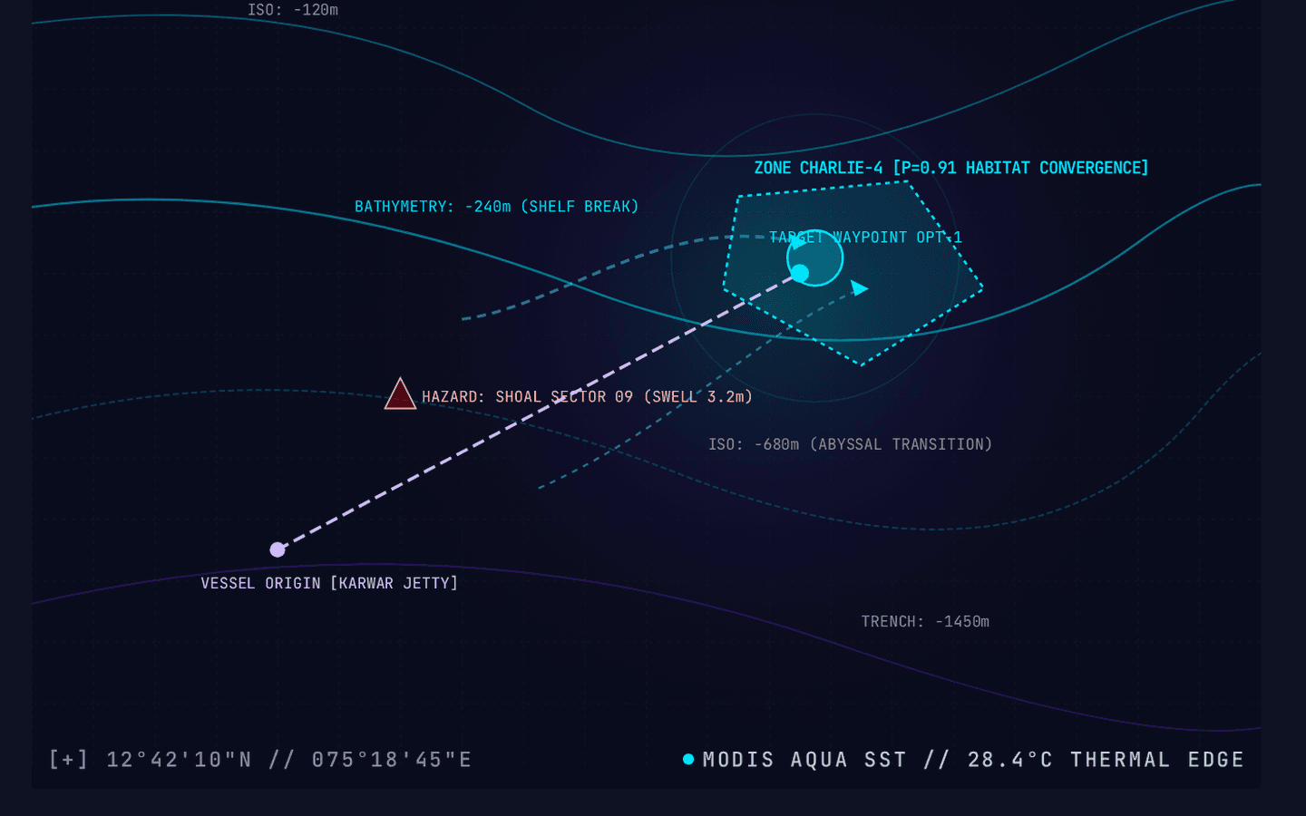
Visualizes bathymetric depth contours (-120m to -1450m) and thermal upwelling gradient fronts.
Delineates habitat probability zones correlated from ocean optic chlorophyll plumes.
Highlights navigation hazard markers (shoal sectors, swell break points, shallow reefs).
Illustrates planned passage trajectory connecting departure point to convergence target.
Low-Connectivity Architectural Design
Engineered with intermittent coastal connectivity in mind
The low-connectivity architecture represents a conceptual design approach for future field validation rather than a currently deployed offline runtime.
Offshore marine zones frequently suffer from severe signal attenuation and intermittent cellular coverage. The ORCA architecture was conceptualized to address these constraints through deliberate state caching and compact synchronization payloads:
Caching high-resolution bathymetric vectors and multi-day meteorological models prior to harbor departure while high-speed shore networks are accessible.
Structuring emergency and squall updates into minimal-byte telemetry packets capable of transmitting over fringe 2G/GSM or low-bandwidth links.
Maintaining navigational waypoints and cached hazard boundaries locally in browser memory without dependency on continuous server heartbeat connections.
Layered Technology Stack
Purpose-fit architecture for intelligence and spatial visualization
Interface
High-contrast spatial frontend optimized for offshore readability and responsive layout.
Application
High-throughput async REST endpoints coordinating agent execution and data dispatch.
Intelligence
Specialized heuristic and model-assisted agent nodes decomposing complex maritime feeds.
Geospatial / Data
Spatial querying of bathymetric contours, marine exclusion boundaries, and harbor vectors.
Personal Contribution & Engineering Role
Distinct ownership areas across system design, AI logic, and product UX
As the lead technical architect on the ORCA concept during the Smart India Hackathon initiative, my responsibilities spanned end-to-end architecture definition, multi-agent workflow decomposition, and interface interaction design:
Architected the modular multi-agent software framework, defining decoupled boundaries between specialized intake agents, the synthesis engine, and frontend clients.
Designed the multi-factor evaluation pipeline, establishing strict prioritization rules where maritime safety guardrails deterministically override commercial catch opportunities.
Designed the high-contrast cartographic interface, ensuring critical hazard alerts and waypoint advisories remain instantly legible on low-brightness vessel displays.
Researched and integrated public oceanographic data standards (MODIS radiometry, bathymetric contour models) into unified coordinate representations.
Built interactive frontend demonstrations and technical defense documentation for the Smart India Hackathon prototyping evaluation stage.
Project Lifecycle & Current Status
Factual position within project development
ORCA was created and developed as an engineering solution architecture and interactive prototype direction during Smart India Hackathon problem exploration.
It validated the feasibility of unifying heterogeneous oceanographic and commercial streams into a coherent decision-support interface. It is maintained as an architectural blueprint and concept prototype, and is not currently deployed as an active commercial service.
AUMByte
Edge AI Crop Disease Detection System